Drogheda grew around a crossing of the Boyne. Its surviving defences, the traditions surrounding Millmount and the painter Nano Reid connect the town’s buildings with the stories told about them.
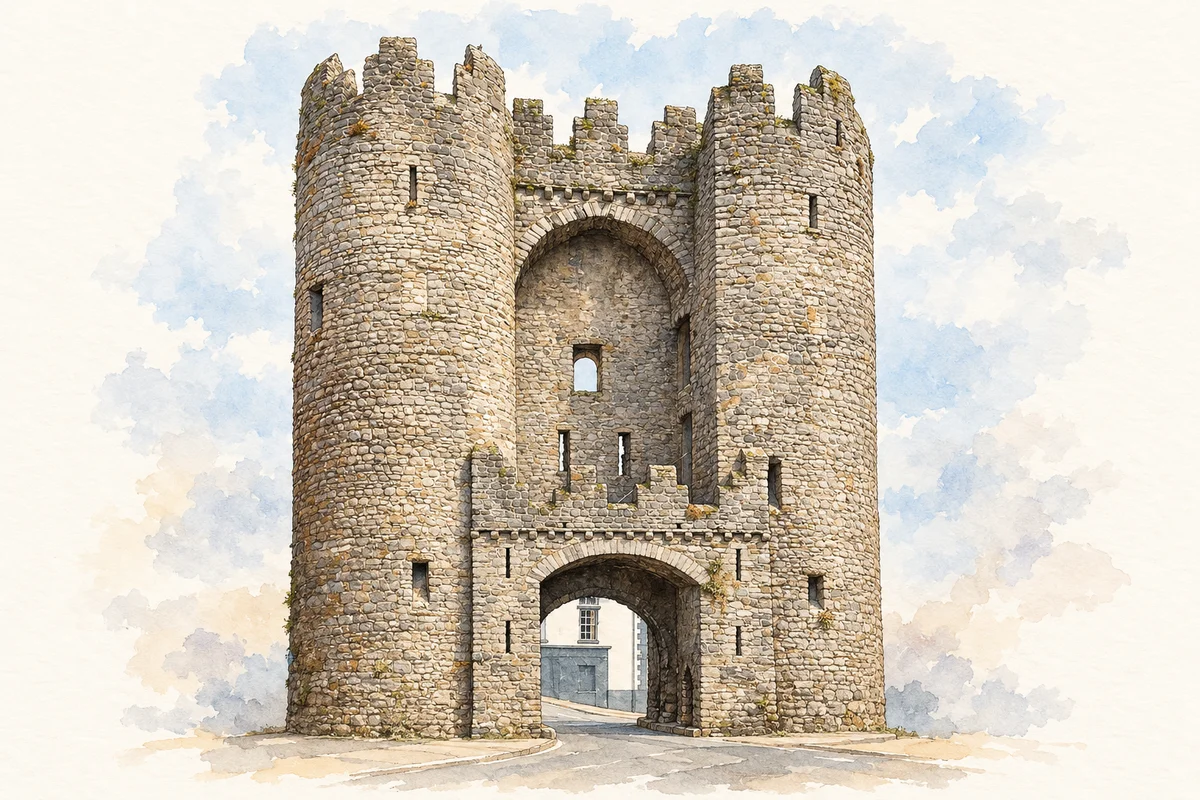
Illustration, St Laurence’s Gate
⊕Recorded locationDrogheda53.71468° N · 6.35044° WInteractive map supplied by OpenStreetMap.
These Irish name elements are associated with this record in the Logainm glossary.
An element’s translation is a clue, rather than a complete explanation of the name. Its form and meaning depend on local history and the full Irish name.
Recorded forms
Droichead Átha· Irish · main form · validated name
Drogheda· English · main form
Place & story
Two boroughs joined across the Boyne
Medieval Drogheda developed as two boroughs on opposite banks of the Boyne: the northern town in Louth and the southern town in Meath. They were united in 1412. Lewis's account records their separate charters and privileges.[2][3]
A murage charter allowed duties on goods to fund the town's defences. Gates controlled access to markets, while the navigable Boyne supported the port. Bridges, quays and walls served the interlocking demands of trade and defence.[3]
The “gate” in the illustration
St Laurence’s Gate is actually a barbican: an outer defensive work that stood in front of a separate town gate. Its paired round towers guarded the approach, with a ditch and drawbridge between the outer work and the gate behind it. The surviving structure dates from the thirteenth century and was heightened in the fifteenth. Its name recalls the Priory of St Laurence the Martyr, reached by the route through the gate.[3]
Folklore & tradition
Millmount and the poet Amergin
Local tradition associates Millmount with the burial of Amergin, also called Amhairgin, the poet of the legendary Milesians. Drogheda’s published heritage interpretation records that association while explicitly noting the lack of evidence that the mound is prehistoric.[4]
The visible fort has its own documented history. The mound formed part of a Norman motte-and-bailey complex, and the surviving tower was built in 1808. It was damaged during the Civil War in 1922 and restored as a cultural centre in 2000.[4]
People & connections
Nano Reid’s Drogheda
The painter Nano Reid (1900–1981) was born in Drogheda and grew up above her family’s public house at the corner of Peter Street and Fair Street. After periods studying and living elsewhere, she returned to the town in 1962. Her connection was also civic: in 1958 she campaigned unsuccessfully to save the medieval Butter Gate. Highlanes Gallery holds her work and archive, and explores the influence of Drogheda’s streets, markets and river valley on her paintings.[5][6][7]
Both counts use the 2016 settlement boundary, allowing like-for-like comparison. CSO supplies the 2022 count on this older boundary for comparison only. The official 2022 Built Up Area has different boundaries.
View population figures
Drogheda — Census 2016 settlement footprint — census population
These are the historical areas published in the 2006 census report. Boundaries may differ between censuses and from modern settlements. Legal towns, environs and suburbs are shown separately; none has been combined into a modern settlement total.
View population figures
Drogheda Borough, Louth — Borough, CSO 2006 report — census population
Drogheda Environs, Louth and Meath — Town environs only, CSO 2006 report
2002–2006: town environs only
6,117people · 2006
These are the historical areas published in the 2006 census report. Boundaries may differ between censuses and from modern settlements. Legal towns, environs and suburbs are shown separately; none has been combined into a modern settlement total.
View population figures
Drogheda Environs, Louth and Meath — Town environs only, CSO 2006 report — census population
These are the historical areas published in the 1996 census report. Boundaries may differ between censuses and from modern settlements. Legal towns, environs and suburbs are shown separately; none has been combined into a modern settlement total.
View population figures
Drogheda Borough, Louth — Borough, CSO 1996 report — census population
Drogheda Environs, Louth and Meath — Town environs only, CSO 1996 report
1991–1996: town environs only
822people · 1996
These are the historical areas published in the 1996 census report. Boundaries may differ between censuses and from modern settlements. Legal towns, environs and suburbs are shown separately; none has been combined into a modern settlement total.
View population figures
Drogheda Environs, Louth and Meath — Town environs only, CSO 1996 report — census population
Figures cover the historical town area printed in the 1986 report. Boundaries may have changed between censuses. Legal town, environs and suburb totals remain separate and differ from modern settlement boundaries.
View population figures
Drogheda, Louth — Borough, CSO 1986 report — census population
These figures use different area definitions. Read the boundary note before comparing them.
Drogheda, Louth — 2011 legal town and environs; 2016 census settlement
Published census settlement populations
40,956people · 2016
Settlement boundaries changed during this period. Differences may reflect boundary changes as well as population change. Where a 2011 legal-town-and-environs count is shown, it has not been recalculated onto the 2016 settlement boundary.
View population figures
Drogheda, Louth — 2011 legal town and environs; 2016 census settlement — census population
St Laurence’s Gate, Drogheda illustration: based on a reference photograph by Andreas F. Borchert. AI-assisted watercolour-and-ink adaptation; street clutter removed, paper margins added. Licence: CC BY-SA 4.0.
 placenames