Townland Names

Paróiste Chléire - Bailte Fearainn
Townland Names of Clear Island Civil Parish, Co. Cork


  The term townland, while unknown in the homeland of the English language it is recognised in all parts of Ireland. The townland division is one of the distinguishing marks of Ireland. It is the established local administrative unit and forms part of the address of most people. On the mainland of Ireland an average townland would contain four or five farms, while on the island of Cape Clear, County Cork the divisions would be considerably smaller. The island measures about 3 and half sq. miles and has 16 townlands. There are more than 62, 000 townlands in Ireland and their names usually represent a certain aspect of geography, climate, vegetation, fauna, or of the economy, language, religion, social customs, or history of people who have lived in the place. Townland names, then, are an important source for the history of people; they constitute the identity of Ireland to both native and visitor. The townland pattern was not imposed on Ireland but evolved naturally as part of the gradual social evolution of the country. The townland system goes back at least 800 years. We have documentary evidence that it was in operation when the Anglo-Normans came in the 1170's. The townland is the natural social unit in the country and is bounded, in the main by natural features or long established man-made features, rivers, streams, glens, woods, prominent rocks, old forts and old ditches. Any country person will know the bounds of his own townland. It is part of the common store of inherited local knowledge. It is what forms part of the address of most people in Ireland.
  The term townland has nothing to do with a town in the modern sense, as stated they are administrative units, subdivisions of the parish with defined boundaries. Cork County consists of 23 territorial administrative units called Baronies. Within each Barony are Civil Parishes and within Parishes are Townlands all of which have a unique name and boundaries that were set by the Ordnance Survey in the 1840s. Today’s Irish towns and cities in are collections of Civil Parishes, with parishes being collections of several townlands.
  The basic townland nomenclature was settled before 1600. Occasional additions and other changes have been made to it since and of course many of the names go back far beyond that date. For the most part they are impossible to date satisfactorily, apart from stating the obvious, that they are as old as their first occurrence in writing.
  The most common form of townland name is the usually descriptive one. Such name as Carraig Mhór, big rock, Coill Liath, grey wood, Droim Mór, big ridge could have been coined 200 or 1,200 years ago. However, it is probable that the bulk of townland names date to between 1300 or 1500 and make up the basic nomenclature of the country. Most townland names are derived from names that were coined by Irish speakers and used in daily speech in Irish only.
In the modern world of today local identity and placename heritage is in constant danger of dying out. Decline in fishing, farming methods, expansion of towns, road building, farms being sold, old people with local knowledge were dying out; depopulation on islands and in rural areas and other factors were contributing to the decline of thousands of names in throughout Cork County every year. The poor translation of native Irish placenames has been extremely destructive of Irish language placename heritage. So it was at Cape Clear and in other West Cork islands and all around West Cork in the 1970s.
  In 1976, Cork City native, Éamon Lankford, began collecting minor placenames at Cape Clear and recorded their location on townland and Parish maps. Over a period of thirty years this initiative was to lead to the creation of the only two County Place Name Archives, in Ireland.
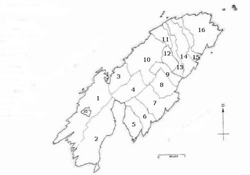
No. Townland Name Abbr. Description of Townland Name
1 Baile Iarthach Thuaidh BIT North-west townland or habitation.
2 Baile Iarthach Theas BID The south-west townland.
3 Cnocán an Choimhthigh CC A small hill named from an O’Cowhig, or the stranger or outsider who might have taken over land from an islander.
4 Coinlín Cn ‘Coinlín’, the Irish word for a stubble area, stubble being what is left of the corn in the ground following the harvest.
5 Gleann Iarthach GI West Glen.
6 Gleann Méanach GM Middle Glen.
7 Gleann Oirtheach GO East Glen.
8 Crathach Thiar CTi Perhaps, the boggy or marshy place, west and east, or the name may refer to the round shape of the most prominent hill in the area.
9 Crathach Thoir CTo Perhaps, the boggy or marshy place, west and east, or the name may refer to the round shape of the most prominent hill in the area.
10 Lios Ó Móine LM A ’Lios’ in Irish was an ‘enclosed area’ for the defence of a habitation site and enclosure for animals which many might call a “fort’. The remains of ‘a fort” was found there in the ninteenth century. The habitation is named from one named Mughain
11 Cnocán na mBairneach CB “Bairneach” is the Irish for limpets which cling to rocks. Perhaps a mound of limpets had built up into a mound on the hillside up from the sea, hence a translater probably recorded, ‘hillock of the limpets.’
12 Cill Leice Fórabháin CLF Perhaps the burial place and ‘grave slab’ of one named Forabhán.
13 Gort na Lobhar GL The Irish word ’Lobhar’ can in speech mean afflicted, decay, decomposition of matter, rotten or worthless. Writers have translated this Irish name to mean’ the field of the leppers ‘implying that the area was used as a place of quarantine for those afflicted with contagious diseases. It could be that the land there was in time past “worthless, so much so that a crop of potatoes ‘ rotted’ there a number of times. This townland name would seem to have derived from a field within it it which still bears the same name.
14 An t-Ardghort A This is the name both of a townland and of a field within it. It is not clear which derives its name from the other but the meaning is clear -the high cultivated field.
15 Ceathrúna Ca ‘Ceathrúna’ / Quarters is a term used in land division.
16 Comalám C ‘Com’ in Irish is a hollow or depression in the land or a “Coombe”. There is a hollow between two hills in this area of the island /‘Oileán’, hence we have a descriptive name, ‘the hollow of the island’.
17 An Bhá Thuaidh C An Bhá Thuaidh is not a townland name but relates to that portion of Long Island Bay on the north side of Cape Clear.

Bailte Fearainn – Paróiste Chléire


Clear Island Civil Parish Map Indicating the Location of Townlands No. 1 to 16 (Figs. 1-11)